Reputedly the toughest trail on the East Coast, this is one long butt-kicker of a hike / run. You need to be in good shape to do this one and also it will involve a bit of logistical planning to hike it through (either you need a car waiting for you at the final trailhead or you need to get back to your car parked at the starting trailhead). The rewards are a real sense of achievement and some great views over the dense forest of the Catskills. I did it as a day run/hike, since I did not fancy carrying a heavy on this tough route, but many people break it up into a 2-day hike.
How long?
1 day or 2 days, 1 night
How many miles?
25 miles / 40 km
How?
Run / hike as a day trip
Hike + wilderness or campground camping
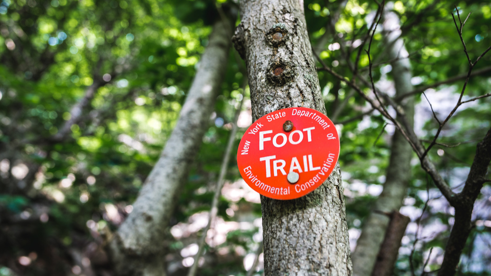
Map required, compass optional (i.e. well maintained & sign-posted trail — just follow the red tags)
Maps?
New York New Jersey Trail Conference Trail Map 141 (Northeastern Catskill Trails)
(You can probably also get a National Geographic topo map to do this route — certainly I saw 2 hikers with such a map on the trail — but whenever you can, get one of the NYNJ Conference maps — they are really high-quality, made by and for hikers, and the profits from the sale go straight back to maintaining the trails.)
Itinerary:
Prediger Road trailhead -> Stony Clove Notch -> Spruceton Road trailhead
Pretty much since I moved to NYC, I wanted to do the Devil’s Path. It is reputedly the toughest hike on the entire eastern seaboard and one of the first things I read about it was that it is one of the deadliest hikes in the US. The latter is also a consequence of the trail being very popular with hikers — the more people on a trail in a year, the more people that can die while on the trail (so it’s partly just a numbers game; rest assured: almost everyone doing the Devil’s Path will make it out alive). So given this almost mythical reputation of the trail, it is a bit of a surprise it took me well over a year and a half to get out and do it. No doubt the fact that you need to rent a car to get up there contributed to why it took me so long to get it done.
The most annoying thing about this hike is that it is one-way and not a loop. So unless you plan to make it a grueling 50 miles out-and-back hike, you need to either drive up with some friend(s) in 2 cars and leave one car at either end of the trail or arrange for a taxi company to drive you from the end to the start, resp. pick you up at the end (the former is obviously much easier as phone signal is not great in the region and you’d anyway would have to wait for the taxi to make it to the trailhead). I organised this trip on a whim on a Friday lunch time, so booked a rental car in NYC to be picked up at 4am on Saturday, and arranged to meet Smiley’s taxi in Tannersville at 7am. I found Smiley’s through hiking forums and sure enough they know all about the trail, will be able and happy to give you plenty of advice and they will also make sure that you’ve got everything you need before you set off (e.g. they tell you that there aren’t really any reliable water sources on the eastern half etc). For a simple hike, the taxi fare ($70 to drive with the taxi from Tannersville to the Spruceton road trailhead, leave my car there, then be driven to the Prediger Road trailhead — all of which took about 1 hour) obviously makes this hike more expensive than most hikes around NYC, but well, if it’s the only way to do it, so be it.
With this set-up it meant I was going to do the Devil’s Path from the East to the West. The eastern half is really what gives the route its name and reputation, so you front-load the toughest bits. If you do it the other way, you get to the hard stuff by the time you are already tired. The route itself is dead easy: just follow the red trail blazes from start to finish. When I did the Devil’s Path the trail was in good condition, except for occasional patches where the summer vegetation had grown over the trail.; but at no time was I at a loss where the trail was headed.
Starting from Prediger Road, the first few miles are quite easy: flat or with just a modest incline. For the first hour I did almost 5 miles (NB I did this as a run/hike, meaning anywhere it was not too steep or dangerous, I would jog/run). But soon enough, the climb proper to Indian Head will come up and it will be steep, no doubt about it.
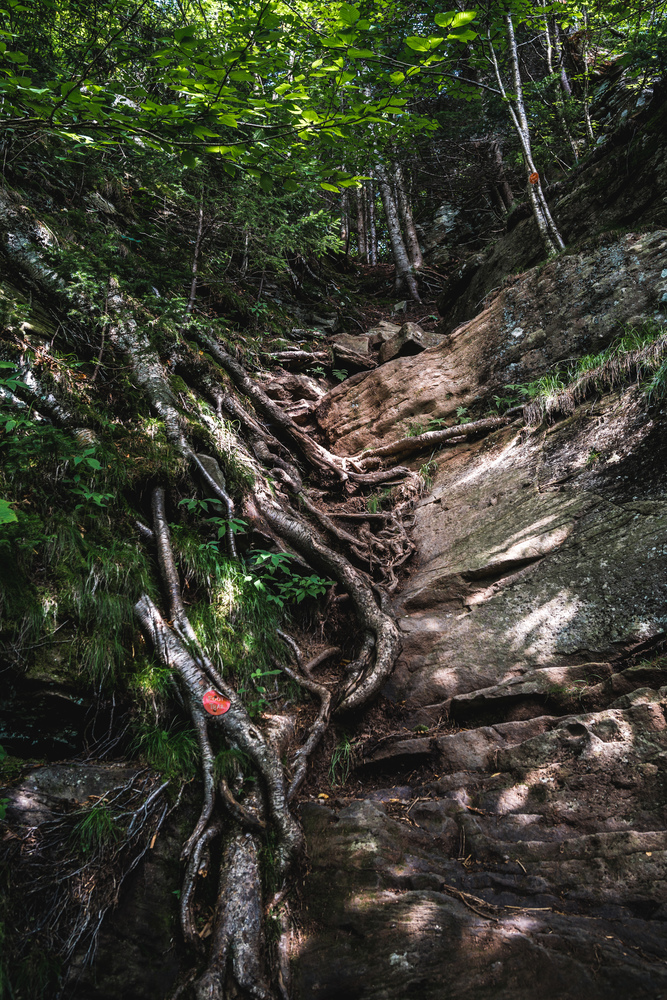
In fact over the next 25 miles you will occasionally have to navigate near vertical inclines, using tree roots and rock features to haul your sorry ass up. But it’s all good fun.
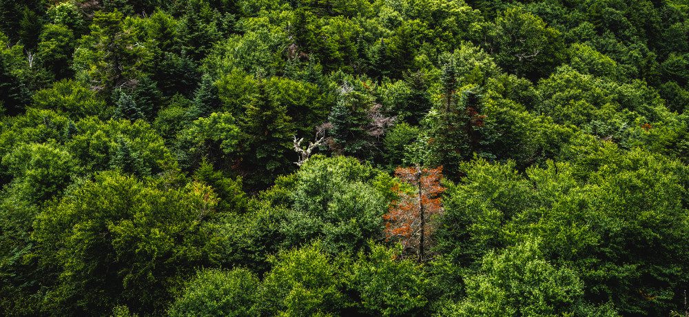
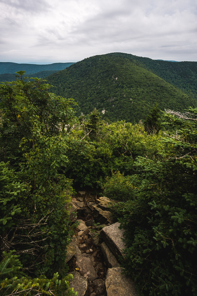
The Catskills have quite dense forest growing throughout and for almost all of the trail you will be hiking / running under a dense canopy, fairly oblivious to anything more than 100 yards off the trail. However, there will be occasional clearings, often rocky ledges, from which you get quite amazing, far-reaching vistas over the Catskills and even the Hudson river. There are really 3 main reasons why people do the Devil’s Path: i) the challenge, ii) the vistas, iii) the fact that you will bag 5 of the 35 Catskill High Peaks (defined as those over 3,500ft height). The 5 peaks you will get are: Indian Head, Twin, Sugarloaf, Plateau (all on the eastern half) and West Kill (on the western half). If you are OK to do 2 short-ish detours, you can claim 2 more: Hunter and Southwest Hunter.
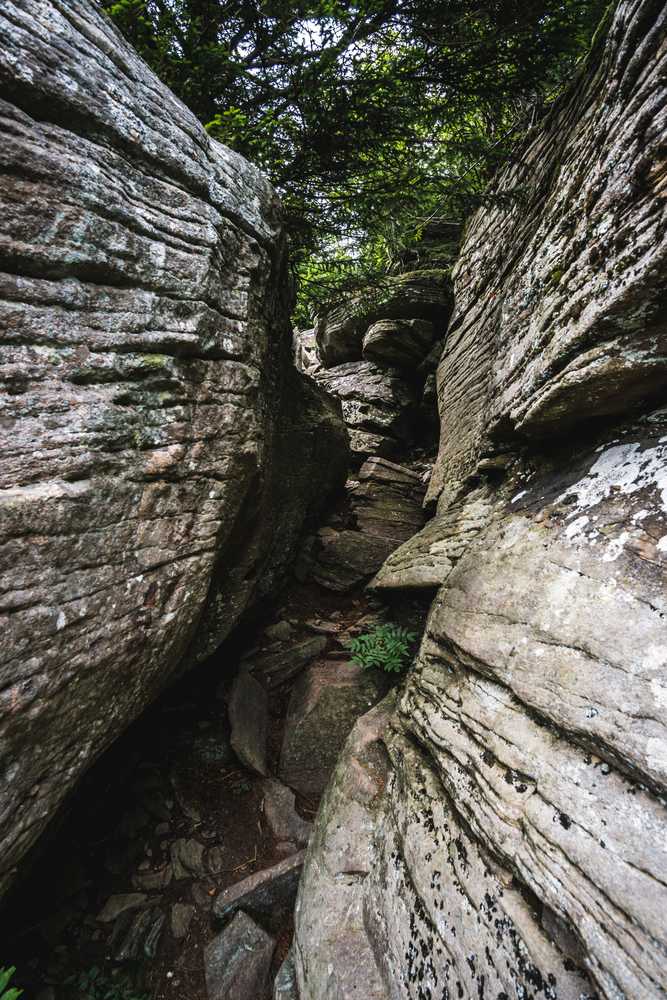
The Devil’s Path is so tough because you go up and down and up and down and up and down. It’s no easy ridge hike. Each and every mountain along the route will need to be climbed from the bottom up. Also, do not underestimate the descents as these can be quite technical. Especially when you come down Twin Mountain, you have to navigate quite a few steep sections and sharp rocks. This slowed my progress quite a bit — you simply cannot run downhill on that stuff.
After Twin Mountsin, the trail takes you up the next Catkills Peak: Sugarloaf Mountain. If you have not felt the effort until now, you will certainly feel fatigue set in by the time you reach the summit of Sugarloaf. It’s another long, tough climb up and the descent from Sugarloaf is quite technical too with several sections of loose rocks and parts where you have to squeeze through in-between rocks. There was a solid rain shower as I made my way up Sugarloaf and this slowed my progress, since for the descents now, the rocks had become wet and slippery, so running was not always possible, even on the flatter sections.
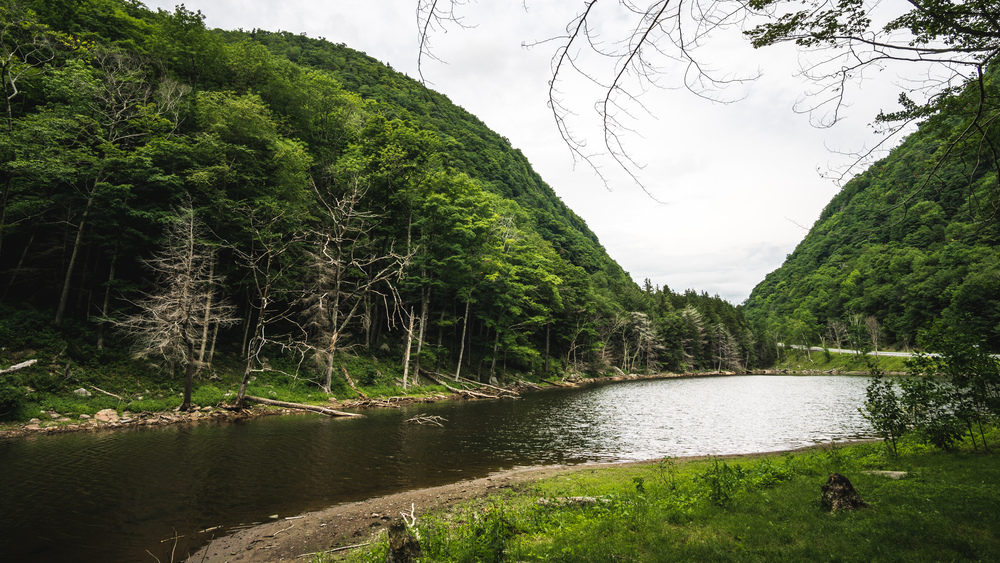
After Sugarloaf you still have to get over Plateau Mountain and once you come down this, you will cross a road: route 214 at Stony Clove Notch. Though you technically have done a bit over half of the distance by now (certainly the toughest bits are done and dusted now), mentally it feels as half-way since the road divides the Devil’s Path into its eastern and western halves. At Stony Clove Notch there is a small artificial lake, Notch Lake, and if you walk a bit down the road there would be a ranger station and Devil’s Tombstone campground. If you plan to make it a 2-day hike and not camp in the wilderness or a lean-to, then this would be your base. Some people also leave their car at the trailhead parking in Stony Clove Notch (note though that parking fees apply at this trailhead), since that gives them the option to pull out half-way.
Anyway, there is a water fountain, so be sure to fill up your water bottle, and, if you did not already have lunch at one of the overviews, here would be a nice enough spot too.
After this, you only have two more significant ascents to make: up the side of Hunter Mountain (you don’t go to the top, you cross the saddle between Hunter and Southwest Hunter; going to the top of Hunter mountain is a 1.6 mile one-way detour, so would add ~3.2 miles / 5km to your route; going to SW Hunter is a ~1 mile one-way detour) and up West Kill. There is a little side-peak to West Kill that you ascend after West Kill which barely looks noticeable on the map, but that last steep ascent comes a bit as a surprise, and you really are tired by then, so be aware it is there waiting for you at the end.
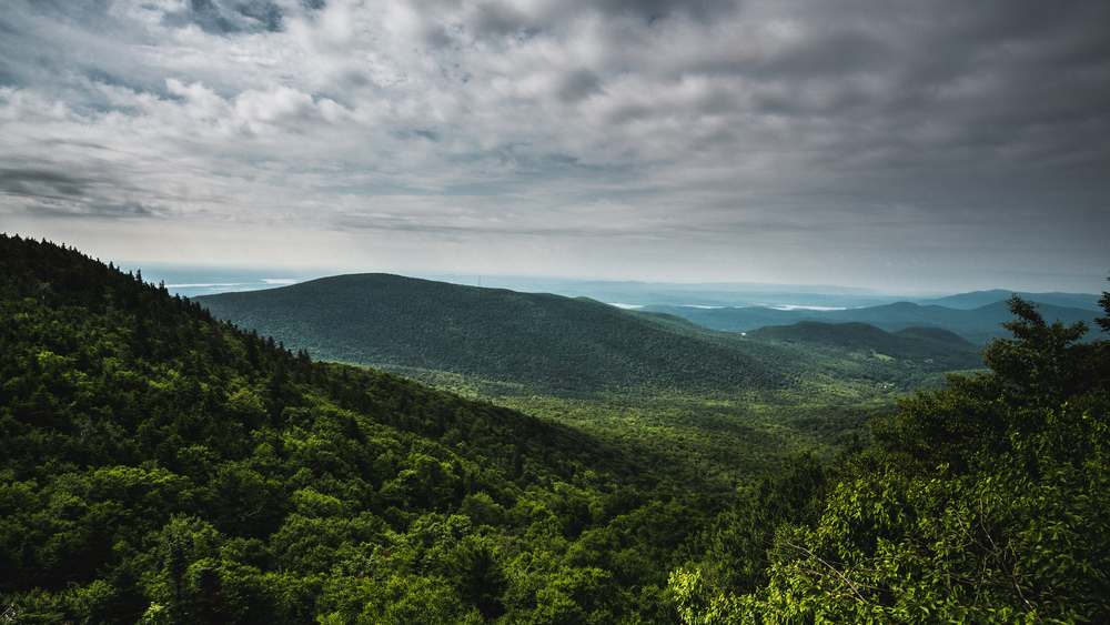
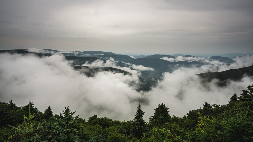
When I started going up Hunter Mountain, it started raining again and except for a short break in the downpour on top of West Kill, it kept raining for the rest of the day. Thankfully, this being July, it was fairly warm and so I did not suffer from hypothermia after becoming thoroughly soaked. Anyway, well prepared, I had spare dry clothes in my day pack, so could have changed if needed. The break in the rain was well-timed as it coincided with my arrival at one of the few viewpoints on the western half. The view from West Kill over the fog- and rain-swept Catskills was quite a sight to behold. I only encountered 3 other groups of hikers on the entire western part — the rain had kept people away (and 2 of those 3 groups were on their way down, after changing their plans due to the rain).
The descent from West Kills is fairly straightforward, though quite long. By this time I just wanted to get it over with: there were no more viewpoints, the forest is quite dense in this part and it was raining hard. The ground had become a wet mess and I slipped a few times — I still ran from time to time, but quite sparingly so; it was just too risky.
When I reached the car, I had been out on the trail for exactly 9 hours. I was a bit disappointed, as I thought I could have managed about 3 hours less, but it is a really tough route and the rain had prevented me from letting rip on the descents.
Final thoughts?
While super tough, I was a bit disappointed by the trail in the end. This is supposed to be the toughest, deadliest and generally most kick-ass trail in the eastern US; yet while some of the ascents are super steep and tough, there was less scrambling involved than I thought and I never once felt in real danger. I have done routes that involved scrambling on loose rock with a 600ft sheer drop to one side (e.g. the Snowdon Horseshoe loop), hence this slight anti-climax. Also, while a nice and rewarding hike, there are fewer viewpoints than you might expect — most of the time you are surrounded by dense bush. Don’t get me wrong: considering you cover 25 miles and numerous peaks, you will get your fair share of absolutely stunning vistas to behold, but you would have thought there would be more of those welcome breaks along the long, grueling hike. Most of the time you are “just” looking at trees, plants, rocks and the trail ahead of you. I am glad I have done it now finally, and as a day hike / run too, but I am not sure I will do it again any time soon (certainly not in its entirety).
Data files (click on the link, then download whatever format you prefer from the gpsies website):
One-way (drop you car at the final trailhead or arrange a pick-up for the end): http://www.gpsies.com/map.do?fileId=grixwiueoyzlljsg
Stephenie
-Great post! Thanks for all the info. Hiked Sugarloaf this winter and we are planning to run/hike the Devils Path in May in preparation for the Mont Blanc Marathon. Really helpful overview of the hike. My real concern is carrying water as I want to keep my vest as light as possible, but sounds like I might need more for the first section than I thought.
marc
-Thanks. I think I carried just one bottle and filled it up at Stony Clove Notch. But it was not too hot a day and raining for most of it, so if there is a bit of a heat wave in May, you probably want to play it safe and carry plenty of water. Of course you could walk some of it, starting from Stony Clove Notch the day before you run the whole route and leave a cache or two… If there’s several of you, some of you could even leave caches on the eastern half and others on the western half…