How long?
3 nights, 3 days
How many miles?
66 miles / 106km
How?
Trail running (or hiking) + hostels
Maps & compass required
Maps?
Ordinance Survey OL17 & OL18
Itinerary:
Llandudno Junction / Conwy -> Snowdon / Pen-y-Pass -> Swallow Falls / Betws-y-Coed -> Llandudnot Junction / Conwy
For accommodation, you can choose what you want: either carry a tent (in which case you probably want to start hiking for a tiny bit after you get to Conwy so that you are at least in the national park when you pitch your tent) or if you intend to run as I did this and hence want to travel lightly, make use of the excellent YHA hostels in Conwy, Pen-y-Pass and Swallow Falls / Betws-y-Coed (that’s why I chose these 3 places as the start and end points for the various legs). This also allows you to leave your pack in the Pen-y-Pass hostel when you do the Snowdon horseshoe loop early in the morning of the second day and hence really put the hammer down for that run (though keep in mind that you ran / hiked ~24 miles the previous day and have to run / hike another ~14 miles later the same day, followed by ~19 miles the next day).
Leg 1: Conwy -> Pen-y-Pass (~24 miles)
The first leg of the trip is the longest and toughest of the 3 legs. Basically from Conwy you run up the Carneddau range, then follow mostly along the ridge. In fact you just bag all the peaks: Drosgl, Drum, Foel Fras, Garnedd Gwenllian, Carnedd Llewelyn and Carnedd Dafydd. When I did this trip, conditions were quite bad on the Carneddau range: lots and lots of fog, rain and mist, but luckily not too much wind. Even navigating my path in that soup was mostly straightforward: for much of it you just have to follow a fence / wall!
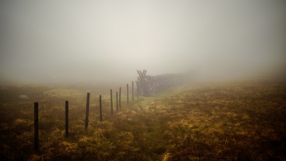
Since you are running along the ridge of the range, some of the undefoot conditions will be bar, broken rocks, particularly when you go over Foel Fras. This is eerily beautiful (especially in the fog) but can make for quite treacherous underfoot conditions, so be careful. This will also slow you down quite a bit.
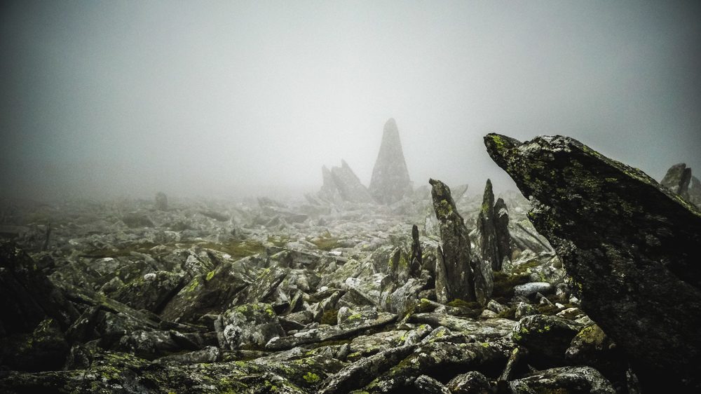
I a sure the views all along the Carneddau range are sublime, but I did not get to see much of it. However occasionally the fog would lift and I would get a glimpse of the impressive surrounding landscape.
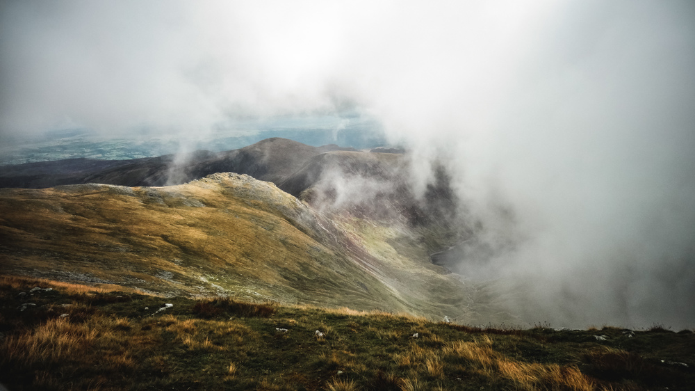
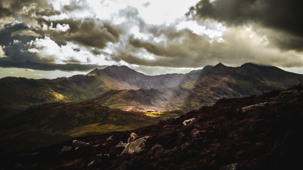
In the end, you need to come down from the Carneddau range and cross the Glyders. Going up the Glyders will be the toughest part of the run as you are well tired by then. The main path would take you down to the eastern end of the Llyn Ogwen lake. However, I would suggest taking the route that takes you over Cwm Lloer: the views you get coming down from there are well worth it (and I got lucky as the clouds finally cleared as I made my descent).
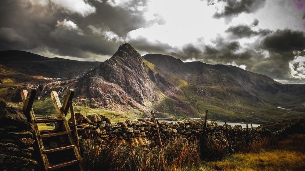
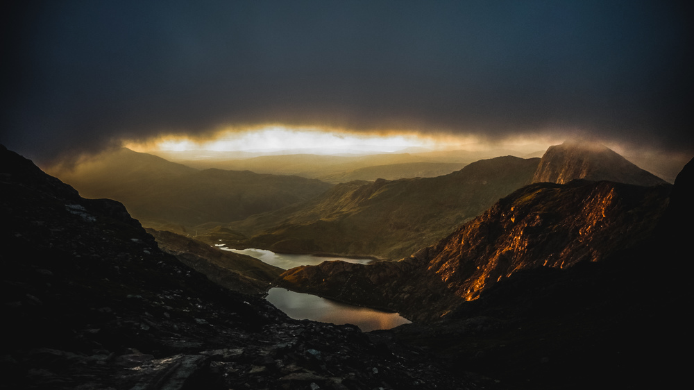
Either way, you go up on the other side of the lake, crossing the Glyders between Tryfan and Glyder Fach. From there you follow the Miners’ Track until you hit the road. Coming down the Miners’ Track you will get a splendid view over the Snowdon massif that will await you on the next day.
Once you hit the road, follow a small trail next to the road until you get to the Pen-y-Pass hostel. And then you get yourself a well deserved pint, dinner and rest!
Snowdon horsehoe loop (~8 miles)
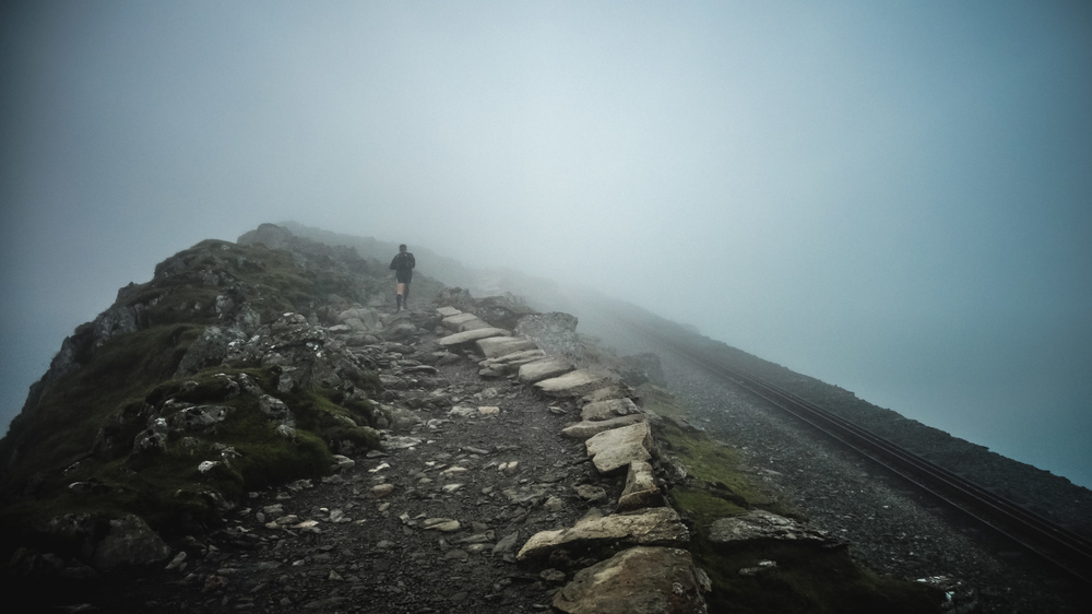
You’ve spent the night at the foot of the highest mountain in Wales, so of course you want to go up to the top! I arranged meeting with a friend from my London running club, Tom, that morning at 5am outside the hostel. Together, and without any equipment except for a bit of water and a point-and-shoot camera, we set off to do the famous Snowdon horseshoe loop while the sun was just starting to get ready to rise. The very top of Snowdon was covered in clouds, but until we got there we were treated to a glorious sunrise.
The ascent is tough and slow, but compared to the speed I managed with my backpack across the Carneddau and Glyder ranges we were going blazingly fast! We had hoped the clouds would clear when we got to the top, but this was not to be. Still eerily beautiful once we got to the top and we were pretty much the only people there at that time.
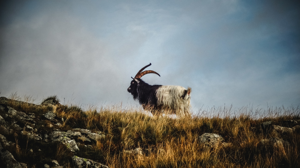
For the descent we chose a slightly shorter route that involved a bit of precarious scrambling next to a sheer cliff (probably a clean 600ft drop; the views are worth it though if you are not prone to vertigo!) before we hit easier terrain and well below 6min/mile pace for the descent. Only a grumpy looking mountain goat slowed us down for a bit.
After this I said good-bye to Tom and treated myself to a hearty breakfast at the youth hostel. Then I packed my stuff and set off on the second leg of the Snowdonia loop.
Leg 2: Pen-y-Pass -> Swallow Falls (~14 miles)
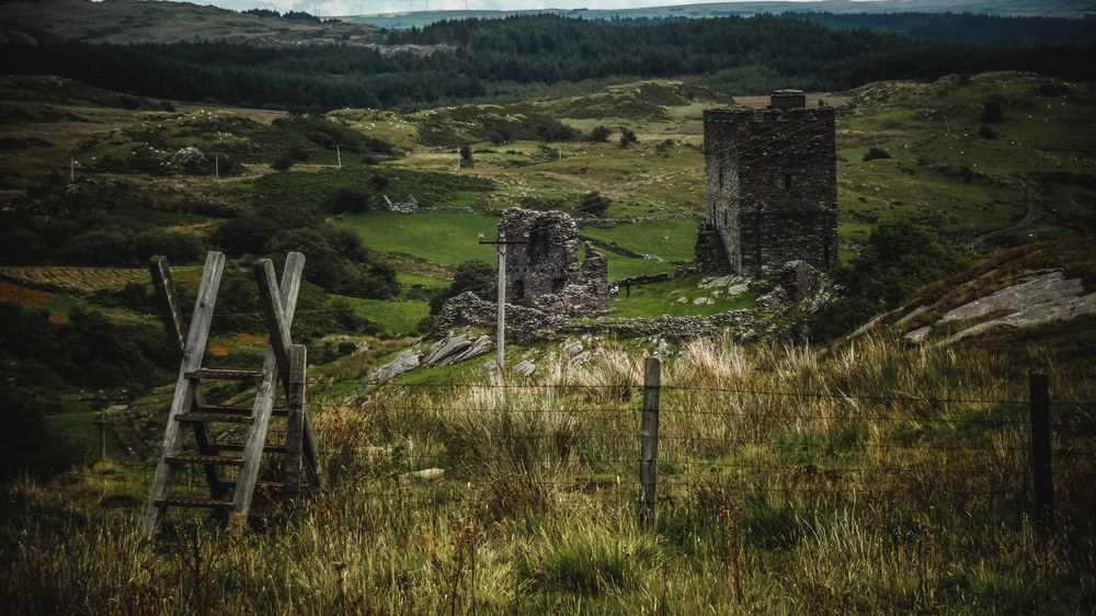
After the tough start to the day, the second leg of the actual loop is much shorter and easier than the first leg the day before. That said, you start by running down into the valley you can see from the hostel, then straight back up on the far end. After you cross that ridge you ran for a bit across an open meadow and then across a forest. When I did this run, half of this forest had been chopped down or blown over and it was incredibly muddy / boggy to cross. Hopefully when you go on a drier few days it will not be quite as bad. After that you run back onto an actual path / trail and follow that past the ruins of Dolwyddelan Castle. You can actually go inside and up the tower, so I suggest you do that and rest your legs a bit and maybe have some food from your pack.
From there I followed the trail some more, but after a while you get to a large open marshland area and, at least when I ran the route, there is no way to see the trail — it’s time to get the compass out. The footing here is quite treacherous and I did not manage more than a fast walk. However you can take comfort that once you crossed this, you will get back onto the trail and from there it is easy to find your way to the hostel near Swallow Falls.
You can visit the falls, but there is a turnstile where you have to pay small entrance fee. When I did this trip, the turnstile was broken and I (and other people too) had to jump the gate.
Compared to Pen-y-Pass the hostel here is much more basic and you will need to get your food in the hotel pub next to it.
Leg 3: Swallow Falls -> Conwy (~19 miles)
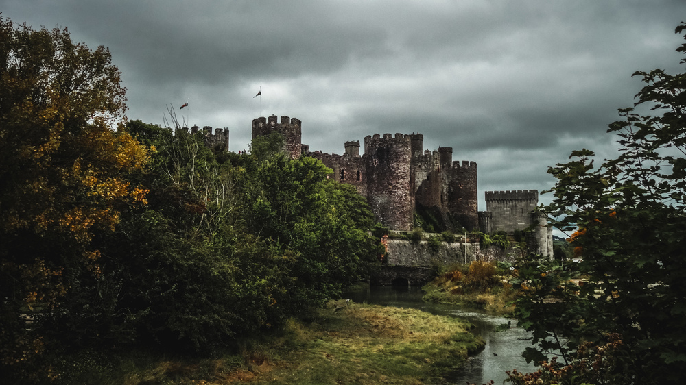
Last day! The start of the route for the last leg is quite delightful: you start by going up the hill on the other side of the river that goes through Swallow Falls, then make you way along a forest road & trail to Llyn Bodgynydd and then Llyn Geirionydd. Finally you find your way to the village Trefriw. From here on I was a bit concerned to be back in time for my train from Llandudno Junction and decided to run mostly along road and to run through the different Welsh villages and towns along the way. Alas this sounded much better when I planned this than it was. Some of the road running is really not that exciting (especially on a grey, overcast day with occasional rain showers). It’s probably tricky to find a route that goes through the national park that is not a repeat of the route from leg 1, but feel free to try. That said it is still a nice run and you really feel happy when you see the ramparts of Conwy castle again.
What would I do differently now that I’ve done this
I’d do this loop again on any bank holiday weekend. However there are probably 2 things I’d try to improve. For one, I would try to change the route of the third leg so that it is less on the road; it’s not the nicest stretch of road running you can find (though you can do a lot worse – believe me!); the only trouble is to find an easily navigable route through Snowdonia National Park without repeating parts of leg 1… Also it will add distance to leg 3, which after two tough preceding days is probably not what you want. For another, I’d probably try to avoid that open marshland on leg 2 — just from studying the map it was not clear that the conditions were going to be so tough on that stretch.
Notes
All pictures in this post were shot with small point-and-shoot camera, hence their much less than professional appearance.
Watch out for cows: many a farmer lets their stock graze freely on park land or land adjacent to the park that you come through. This is particularly true for the third leg. I was chased by one bull on one occasion and a cow watching her calf on another one.
Data files (click on the links, then download whatever format you prefer from the gpsies site):
Leg 1 (Conwy -> Pen-y-Pass): http://www.gpsies.com/map.do?fileId=qlldmpubvzpotsxl
Snowdon horseshoe loop: http://www.gpsies.com/map.do?fileId=yfxfexnzlgtxetav
Leg 2 (Pen-y-Pass -> Swallow Falls): http://www.gpsies.com/map.do?fileId=bqkczubkvxvhdqzn
Leg 3 (Swallow Falls -> Conwy): http://www.gpsies.com/map.do?fileId=ropysbhzkunpkzfi
Complete route: http://www.gpsies.com/map.do?fileId=hrgesegtiwcgxckb