How long?
2 days, 1 night
How many miles?
540 miles / 870 km (without the overnight hike; that one is ~15 miles one-way)
How?
Road trip + wilderness / backcountry camping
Map required, compass optional (i.e. well maintained & sign-posted trail — anyway you just have to follow the river)
Maps?
Satnav / phone for driving or Washington / Seattle / Olympic Peninsula road map
National Geographic Trails Illustrated Map #216 (for hiking and driving on the Olympic Peninsula)
Itinerary:
Seattle Airport-> Seattle (optional) -> Hurricane Ridge -> Ruby Beach -> Graves Creek trailhead -> Kalaloch -> Seattle Airport
Leg 1 (Seattle Airport-> Seattle (optional) -> Hurricane Ridge -> Ruby Beach -> Graves Creek trailhead):
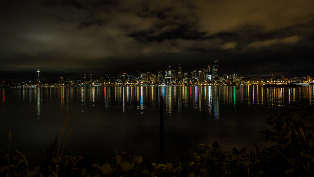
My flight was scheduled to land at SEA at midnight, but we came in about an hour late. My plan had been to take a short drive north from the airport and cruise through Seattle at night. The drive from the airport to Hurricane Ridge takes about 3 hours and I wanted to be there in time for sunrise, which was at around 5.30am (late July). The drive up to Seattle is about 20-30min. So while there was still plenty of time to drive up, there was not much time / point to actually drive leisurely through Seattle, so I just drove to Harbor Avenue in West Seattle and enjoyed the skyline, with the iconic Space Needle (built for the 1962 World Fair), from there. Now if you’ve already been to Seattle or don’t care much about cities, then skip this detour and head straight fir the Olympic Peninsula — you will be able to catch one or two hours’ sleep in your car after you arrive. I had slept on the flight over from NYC and while my body clock complained just a bit, this was enough to keep me going and so I happily went for the detour to Seattle.
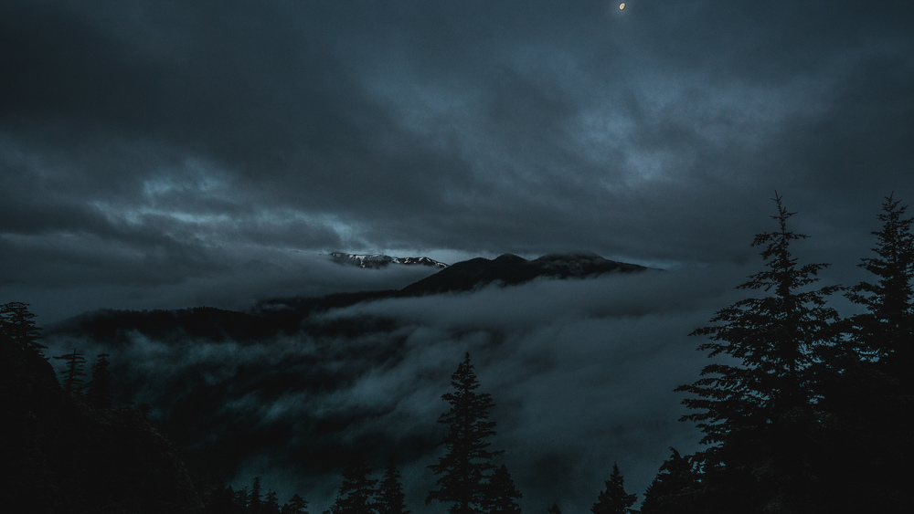
After that it is an easy drive over to Hurricane Ridge (take the interstate 5 south, then follow routes 16, 3, 104 and finally 101). There were occasional rain showers and plenty of fog as I drove to the national park, so you should really be able to be super alert in the car. I was a bit concerned that there was not going to be much of a sunrise in this sorry weather, but as I drove up Hurricane Ridge road (N.B.: if you do not have an interagency park pass, don’t forget to pay your fee at the machine at the park entrance) with twilight in full swing, the clouds started to break (or rather, I was driving up out of the low clouds) and I started to get a glimpse now and again of the mountains looming before me, with extra mood provided by the moon.
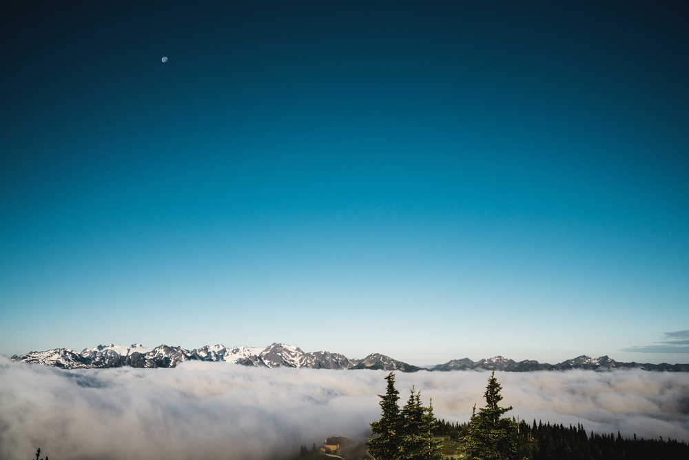
Finally up on Hurricane Ridge, there was fog initially, but it lifted and there were stunning views to be had. The clouds were all lying in the surrounding valleys and you really got the impression of towering over a sea of clouds, with only the high mountains piercing through. There is a short trail you can do from the parking lot (half a mile or so in total length) which takes you to an aptly named Sunrise Point, but with great views all along the trail (see the magical fog-shrouded landscape that presented itself to me on this trail as captured by the feature image for this post).
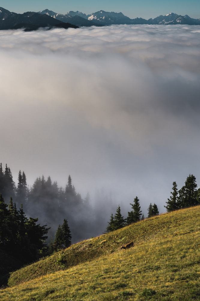
I regretted not taking my tripod with me as there would have been excellent material for capturing time-lapses of the slow moving clouds in the valley. Anyway there were great pictures to be taken. On the meadows next to the visitor center, a couple of deer came up from the valley and out into the sun, munching happily on the grass.
If you brought picnic, this would make for a great picnic spot. I had not (or rather had eaten my sandwich on the flight) and so was getting a bit hungry. The visitor center would have been convenient but it only opens at 9am, so after having had my fill of the views, I drove down to Port Angeles and had a good heart breakfast at a place called Cafe Garden.
After this, I headed back up to the visitor center in Port Angeles to get my backcountry permit for the night. If you want to do one of the quota limited hikes (e.g. Upper Royal Basin), then it might be best to first get the permit as soon as they open, as there will be a queue of people. I had decided to hike into the Enchanted Valley where there are no limits, so satisfied my hunger first, then went to the backcountry office, after the early queue had cleared.
From Port Angeles I headed for Ruby Beach – a solid 1h45min / 2h drive. Shi Shi Beach might be more impressive (I don’t know as I did not go), but is is a detour and requires you to hike a few miles for none of which I had time, as the hike to Enchanted Valley is a whopping 15 miles long… But if you plan to stay in a guest house somewhere, or do your overnight hike to Shi Shi Beach (my original plan, but reports of serious mosquito trouble and ~100-200 people camping out there on a summer weekend, I decided against this), then by all means do this.
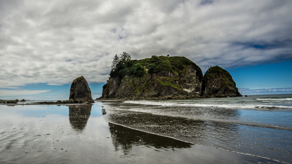
Ruby Beach is conveniently situated along the route from Port Angeles to the Quinault rain forest area, and you only have to hike a quarter mile from the parking lot to the beach. While popular, you will still be awestruck by how wild this beach looks, with Abbey Island towering over it. Ideally the tide is low when you get there (I had of course planned this to perfection…) and you can hike a mile or so up north along the beach. If you’re more flexible with time, hike up the full 3 miles or so to the mouth of the Hoh river and then back down (but really only do this if you have studied the tide chart before setting off as you otherwise risk having your way back getting cut off!). Also, apart from the barnacles, clams, snails, crabs etc that will abound in the tide pools and rock face, keep a look out to the ocean for sea otters and whales. I saw one sea otter hunting just south of Abbey Island. For this it is a good idea to bring a solid pair of binoculars with you as the otters will be quite a bit out at sea.
I still had good 5-6h hike before me, so only went up for a mile or so, then headed back, got into my car and drove to Lake Quinault and the Graves Creek trailhead.
Hike (Enchanted Valley):
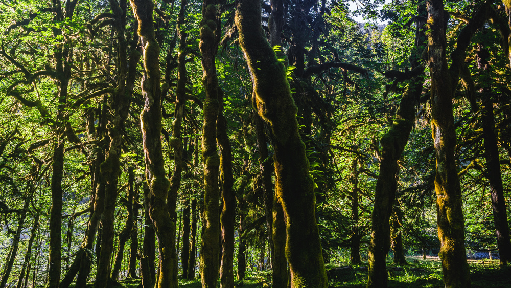
See my detailed post on this hike here. It’s a nice, but long hike. You will be walking mostly through old growth forest, going up the east fork of the river Quinault. The namesake valley is truly deserving of its name and in spring you should be almost guaranteed to see bears here (good to know if you want to avoid bear encounters!). However if you just want to get a maximum of scenery in, then consider trying to get a permit for the Upper Royal Basin, which I hear should be nothing less than spectacular. If you do this, then you might have to adjust the route for this road trip, as your trailhead would be in a quite different part of the park.
Leg 2 (Graves Creek trailhead -> Kalaloch -> Seattle Airport):
If you follow my route, then your day starts with another 5-6h hike: back the way from Enchanted Valley to Graves Creek trailhead. By the time you are back at the car it is lunch time, and there is only so much you can still hope to do, given that you have to catch a flight from the Seattle-Tacoma airport in the evening (if you only got the weekend as I did).
Now the sea otters had quite gotten to me the previous day, so I decided to head back up to a beach to see if I could spot some more. I stopped at Kalaloch, as there was a gazebo up above the beach from which it as much easier to have a good view then down from sea level. Sure enough there were 2 groups of a dozen otters each hunting near the Kalaloch rocks.
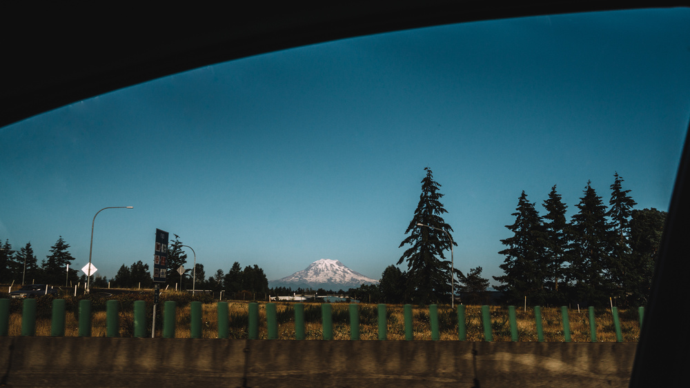
After also getting some late lunch here, I got back to my car and set off for the long drive back to the airport. If the weather is clear then Mount Rainier will loom up spectacularly along the highway at times, so enjoy the drive even if the traffic on a Sunday late afternoon / evening might be bad at times (as it was in my case).
Final notes:
A great little trip, but really a weekend does the park no justice. I did not get to see Shi Shi Beach or hike up in the mountains proper. So I will be back for sure and stay longer than just 2 days, 1 night. But still, considering how charged my weekend was and how much I got to see, it’s difficult to see how to cram in more into such a short time.
Data files (click on the link, then download whatever format you prefer from the gpsies website):
Leg 1 (Seattle, Hurrican Ridge, Ruby Beach, Quinault area): http://www.gpsies.com/map.do?fileId=wotoposopswojapn
Leg 2 (Quinault area, Kalaloch, Seattle): http://www.gpsies.com/map.do?fileId=lwkreedupfxfbyjw
Complete Route: http://www.gpsies.com/map.do?fileId=nzhdhjrbuhayitcq