How long?
1 day or 2 days, 1 night
How many miles?
14 miles / 23 km
How?
Run / hike
Maps?
Satnav / phone for driving from Blantyre or Lilongwe or a Malawi road map (Note: the road from Mulanje to Likhubula is unpaved and can be rough in places).
For the route (and alternative hiking routes), consult the excellent hiking guide and maps from the Mountain Club of Malawi: http://www.mcm.org.mw.
Itinerary:
Likhubula -> Skyline Path -> Chambe Plateau -> Lychenya Plateau -> Milk Run Trail -> Likhubula
“60 seconds!”
[5 seconds later]
“24 seconds!”
[8 seconds later]
“10 seconds!”
[2 seconds later]
“5 seconds!”
“6 seconds!”
[5 seconds later]
“6 seconds!”
“5 seconds!”
“4 seconds!”
“4 seconds!”
“3 seconds!”
[5 seconds later]
“3 seconds!”
“1 second!”
“Get ready!”
“Set!”
“Go!”
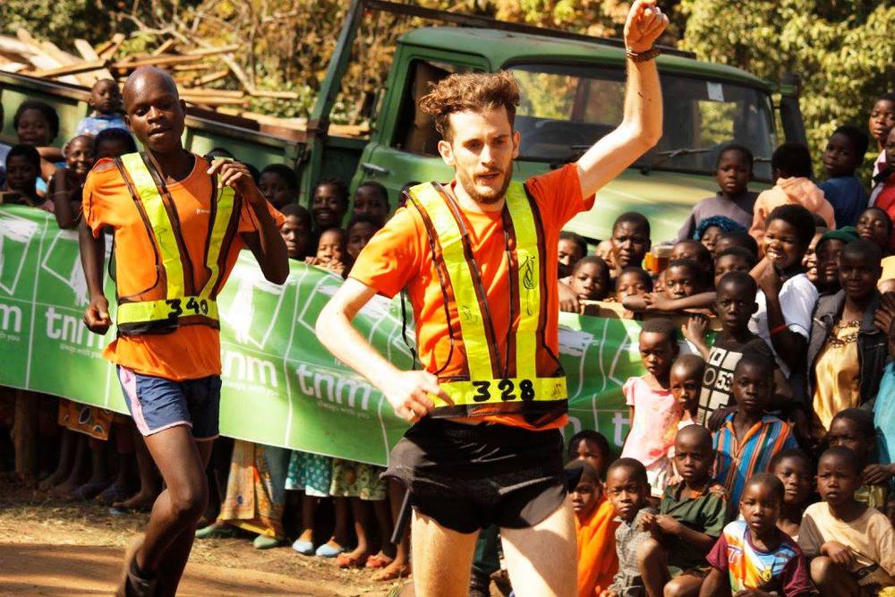
With this weirdly time-warped countdown, the 2017 Mount Mulanje Porters Race got under way – at 7.03am for a scheduled 6am start. Preceding this had been a joke start which most people luckily did not take seriously. Anyway it set the mood for what was to be one hell of a race. Fiendishly and relentlessly tough, yes, but great fun, mercilessly humbling (no matter how good a runner you think you are, you will find yourself getting beaten by barefoot 15 year olds and maybe also the occasional woman running, equally barefoot, in a full dress) and above all, unbelievably scenic.
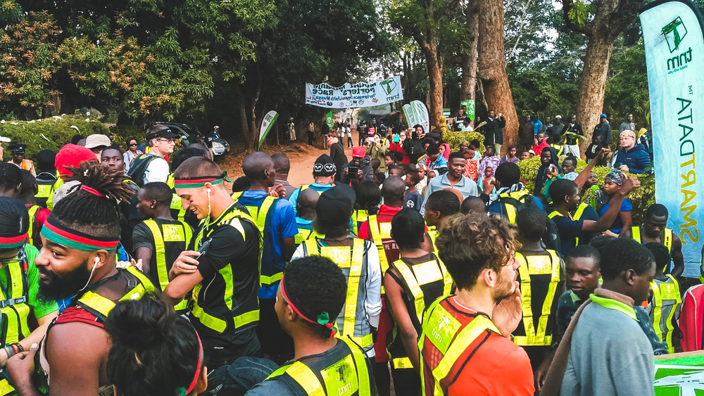
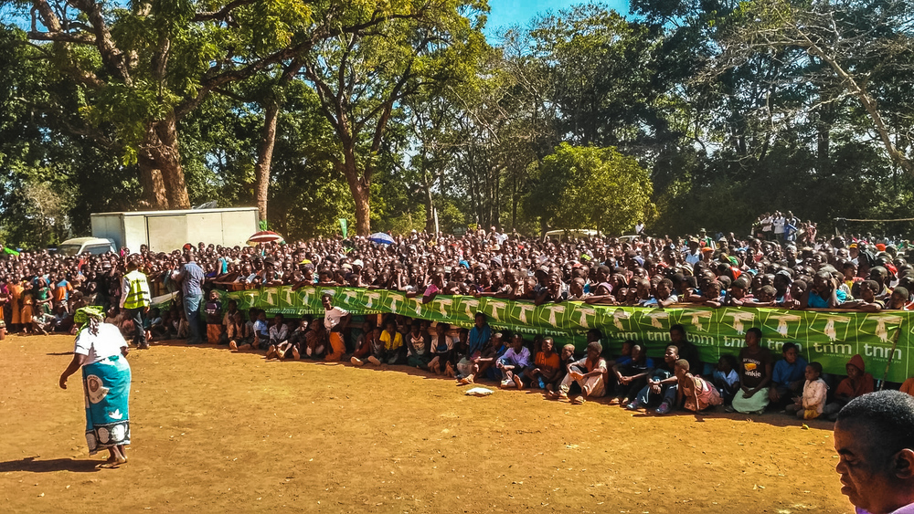
The Mount Mulanje Porters Race is held annually, on the second Saturday in July, since 1996 when it was limited to the porters and guides on Mount Mulanje. Nowadays it is open to local, national and international runners, and attracts about 400 participants. After the race there will be concerts in town as well as food and drink – a big party really, not to be missed. So should you plan to visit Malawi at some point in the future, make sure you plan your trip so as to be in Likhubula in July.
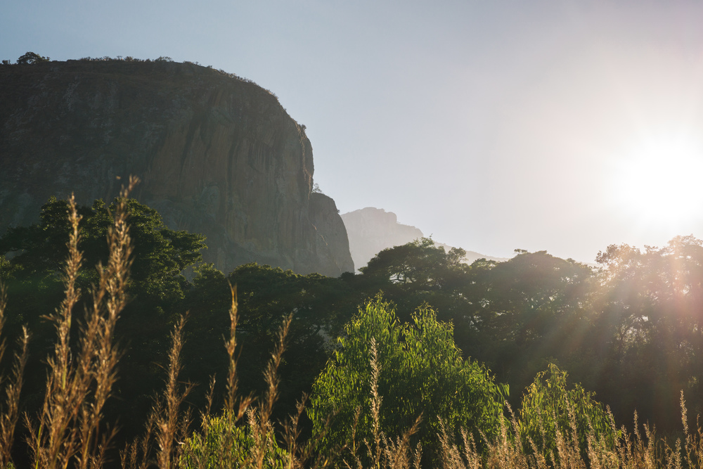
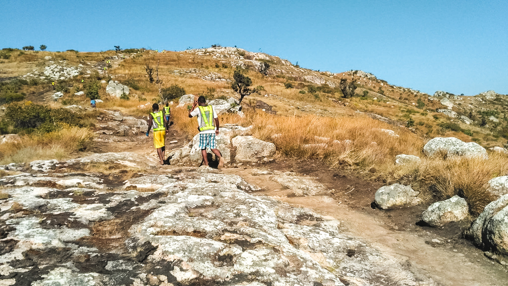
The race takes one of the steepest (none are easy) ascents to the Mulanje, the Skyline Path. So-called because of an old cable runner that was used to haul gear up to the mountain (you can still see it – though if racing, you might have other things on your mind than looking for it), it is mercilessly steep and rocky. Since you will do this early in the morning it is, at least, in the shade. Though it’s less than 5km to the top from Likhubula, you will climb about 1000m in altitude, and consequently this will probably take up to a third of your total race time.
Once you reach Chambe Plateau (there’s a checkpoint here – make sure to get your bib marked), if you paced yourself correctly on the ascent, you can put the hammer down: while still undulating and at altitude, you can run at a decent pace, power-walking the few short inclines on the way to Chambe Hut. You will run along the impressive west face of Chambe Peak – at 1700m the longest vertical rock wall in all of Africa no less.
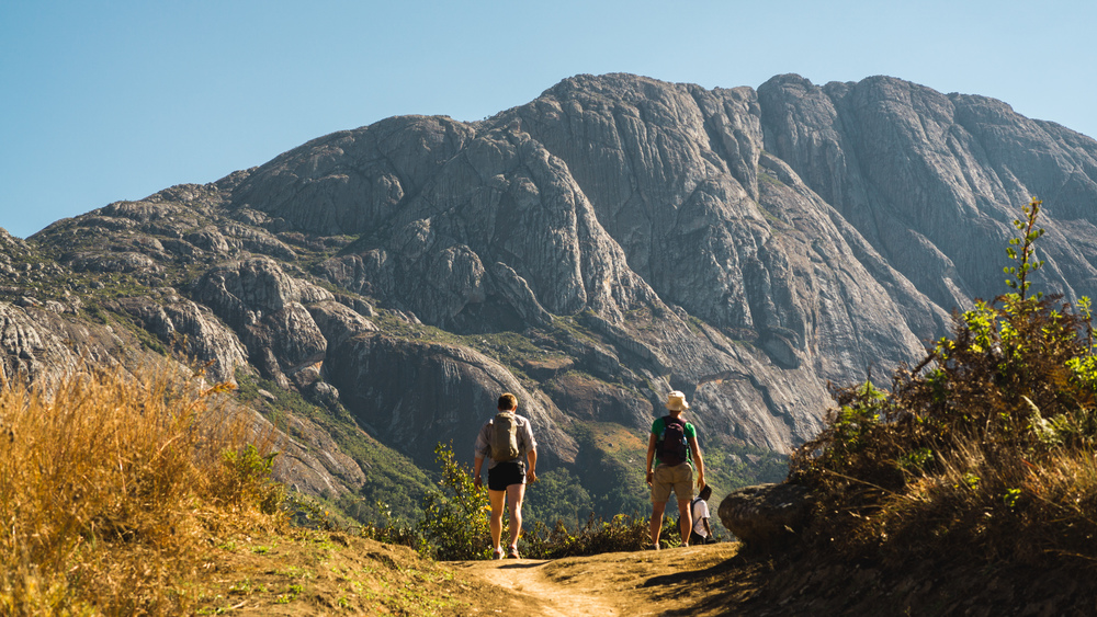
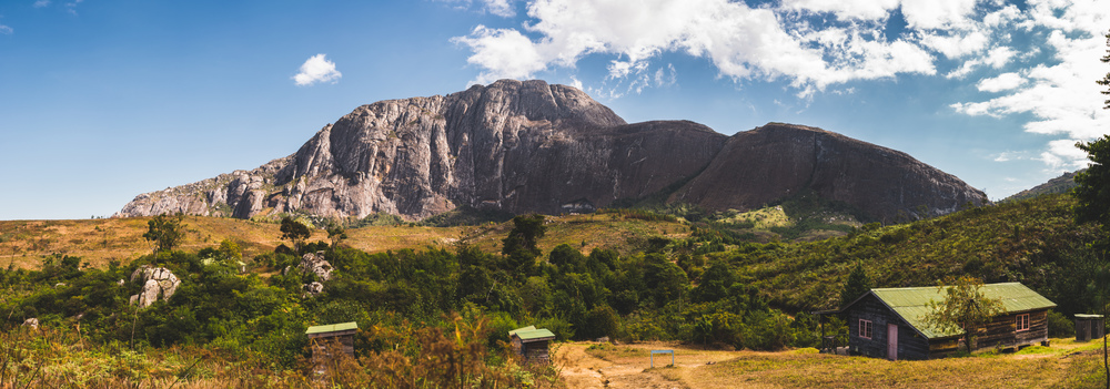
If you are not racing, enjoy the views of Chambe, especially when you get to the picturesque Chambe Hut where you can load up on water, and even sodas. Just as for the other huts on Mulanje, you can spend the night at Chambe Hut. You cannot book the huts in advance and in general no-one showing up at the huts will be turned away. So on good weather weekend nights, some of the more popular huts (Chambe is one of those) can be quite busy with fellow hikers. Be advised that nights in winter can be very cold, so pack accordingly.
After Chambe Hut, there will be another noticeable incline and from here onwards it’s a lot of up-and-down until you get to the descent. Power-walk the ascents, blast down the less technical descents and be careful on some of the steeper and rockier downhills. On your way over to Lychenya Plateau you will cross the Knife Edge – stunning views over valleys on either side of you. Of course during the race, you won’t really be able to enjoy these fine views. After the Knife Edge will be a second, and, at least in 2017, final checkpoint – again make sure to get your bib marked.
You will reach the highest point of the course just before you set off on the descent. It’s a long steep-ish incline and you will start to feel quite tired by now. Note that if your legs have given by this point, you will be in trouble: the upcoming descent is incredibly technical and will take a toll on your leg muscles, so make sure you hold back earlier in anticipation of this.
The descent is brutal, steep and seemingly endless. Going down fast here is nothing for the faint-hearted and the slightest misplaced step could spell disaster – so be sure to be careful. If your race is anything like mine, you will get to appreciate the supremely elegant descent racing by Malawian mountain runners.
This part also had one of the funnier moments in the race: on a piece of slickrock marshals hand out bananas much welcomed by tired runners. However for the next mile or so, you will have to dodge the banana peels along the route – as if it was not dangerous enough with all of the sharp rocks. Somehow this felt like being in Super Mario Kart!
You will criss-cross a number of streams that run down the mountain face, and after a long straight patch, you will take a right turn, cross a set of rock pools (big crowds cheering you on here), and from there it is a short dash to the finish line.
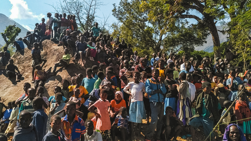
You won’t recognise Likhubula upon your return. There are thousands of people at the Forestry Office now, all eagerly watching the finish of the race and waiting for the party to start. It’s a joyous atmosphere, and really a great finish to a great race.
Whether you ran or hiked, a fantastic idea is to trace back your steps to the pools and take a well-deserved and most welcome dip in them to cool down and help your legs recover (a bit).
Notes:
As a shorter alternative (e.g. for a 5-6 hours day hike), you can backtrack from Chambe Hut, then come down via the Likhubula Falls. This option comes to about 16km and the descent is somewhat less technical and significantly shorter than the Milk Run. Crucially from after Chambe Hut there is no further climbing along this route.
Finally, there’s some pretty cool drone footage from the 2015 edition of the race on youtube:
Data files (click on the links, then download whatever format you prefer from the gpsies site):
Porters Race loop: http://www.gpsies.com/map.do?fileId=ejldbzvrhyamfdmk
Alternative (shorter) loop: http://www.gpsies.com/map.do?fileId=fctcgoeecbcpwhxi
]]>