How long?
2 nights, 2 days
How many miles?
~1,000-1,100 miles
How?
Driving
Phone / GPS recommended; for the backpacking part a map and compass are required
Maps?
National Geographic Trails Illustrated Map #239
Itinerary:
Denver Airport -> Mount Rushmore NM, SD -> Devil’s Tower NM, WY -> Badlands NP, SD -> Minuteman Missile NHS, SD -> Denver Airport
N.B.: There are airports closer by, but they are much more expensive to fly to. Feel free to change the starting and ending point — it’s a long drive up from Denver!
Leg 1: Denver Airport -> Mount Rushmore NM, SD -> Devil’s Tower NM, WY -> Badlands NP, SD
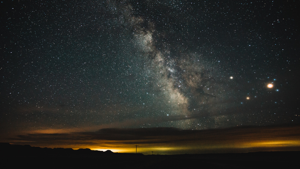
So it’s kind of difficult to find a reasonably priced flight to South Dakota. Hence Denver, a major US hub airport, is your best bet. The only problem: it’s a solid 6h drive away from where you want to get to. Anyway if you come from the East Coast, you can take a Friday evening flight, be in Denver at around midnight or so, then drive up and be at Mount Rushmore just after sunrise (unless you do this in winter). This makes for a long drive through the night. Be sure to get some shut-eye on the flight or you are putting yourself in serious risk of causing a sleep-drive accident. With this disclaimer out of the way, I king of like driving on empty country highways at night. If the skies are clear, and there is no moon out, you should make a few stops along the way and gaze at the sky. That’s exactly what I did and it was amazing. At 3am in the middle of nowhere in Wyoming, the skies are amazingly dark. Also when I did this trip (May 2016) there was a cool Saturn and Mars constellation up in the sky. Mars was super big and bright and it was quite a show. A few such stargazing stops help to break up the long drive and shake out some of that fatigue.
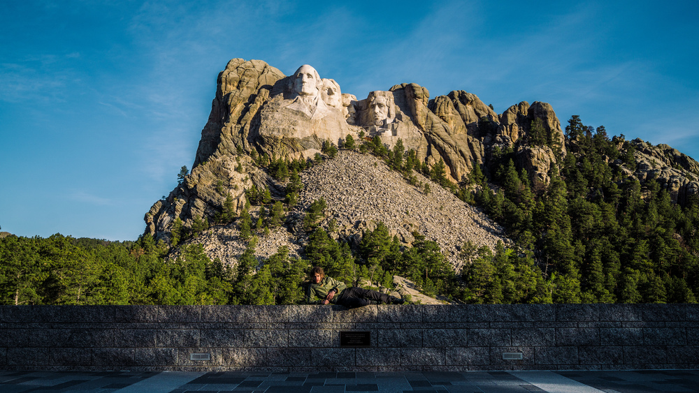
The advantage of that long drive through the solitary night: you will be at Mount Rushmore at around 6am. The visitor center, cafe and gift shop will still be closed, but that also means that the parking lot is free (otherwise it’s $8 or so, I believe). Further, I was the only one at the memorial this early in the morning: it was brilliant. It was a nice, crisp sunny morning and doing the short hike that loops around at the base of the morning was a quiet, pleasant affair. I took my time, enjoyed the scenery (the Black Hills really are gorgeous; next time I go, I sure plan to spend more time there and also visit Custer State Park), then as soon as the cafe opened, I went in and had a good hearty breakfast. The waiter also showed me where the original cafe, the one that is featured in North By Northwest (a favourite film of mine and prime reason for wishing to visit Mount Rushmore), had stood and that they in fact had to reshoot the cafe scene in the studio back in LA as the film they shot over here was damaged during the shipment to the West Coast.
After you had breakfast, head back to your car: there’s still plenty of driving to do for the day. Next up is another iconic film location (this time Spielberg, not Hitchcock; Strange Encounters of the Third Kind): Devil’s Tower in Wyoming. It’s roughly a 2h to 2 1/2h drive to get there from Mount Rushmore.
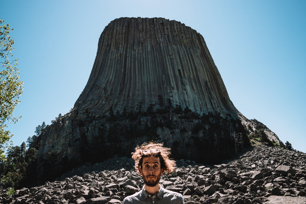
Even though you know is going to be waiting for you, seeing that cylindrical monolith of a rock jutting out into the landscape is just breathtaking. It’s a really surreal and bizarre natural feature. Turns out it is not fully understood how this rock came into being. Most commonly it is believed that molten rock was pressed through the sedimentary rock beds (hence those weird vertical columns that run around the face of the tower) and then the much more solid tower emerged over the years as the surrounding sediment was carried away by the Belle Fourche river. However it could also be a volcanic plug and there are a few other theories as to how the tower came into existence. Certainly the most poetic explanation is the old Lakota tribe legend. This story has a bunch of girls being chased by giant bears. They run, but then stop and pray to the Great Spirit to be saved. This Great Spirit then raises the earth around them and the girls are safe from the bears. The latter try to climb atop, but they fail to do so and their claws leave deep scratches on the sides of the hill — the vertical columns that you can still see today.
There’s two nice circular hikes around the tower; a short on and a long one. I did the short one and it was quite pleasant. Don’t forget to scan the sides of the mountain for climbers — this will put the scale of the thing into perspective.
When you are done: back to the car — more driving awaits. After this you want to drive out to Badlands National Park — this is where you’ll spend the night. It’s an almost 3h drive to get there. You’ll drive through a lot of empty countryside, but you’ll also have to go through Rapid City and a little town called Wall in South Dakota.
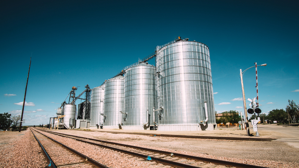
The main attraction in Wall, SD, is a shop: the Wall Drug Store. It used to be a small drug store with very little business back in the 1930s, until the owner had the great idea to put up adverts for free ice water on the highway that lead to the then new Mount Rushmore monument. Since then the store has become hugely successful and nowadays it is a huge mall, way too big for such a small town as Wall. Anyway they still serve free ice water, but other than that it really is just a gigantic tourist shopping mall. I stopped there out of curiosity, but feel free to just skip this. I appreciated the large silos next to the railway more than the Wall Drug Store to be honest. Anyway, if you haven’t had lunch yet, the town is a good bet to get some food.
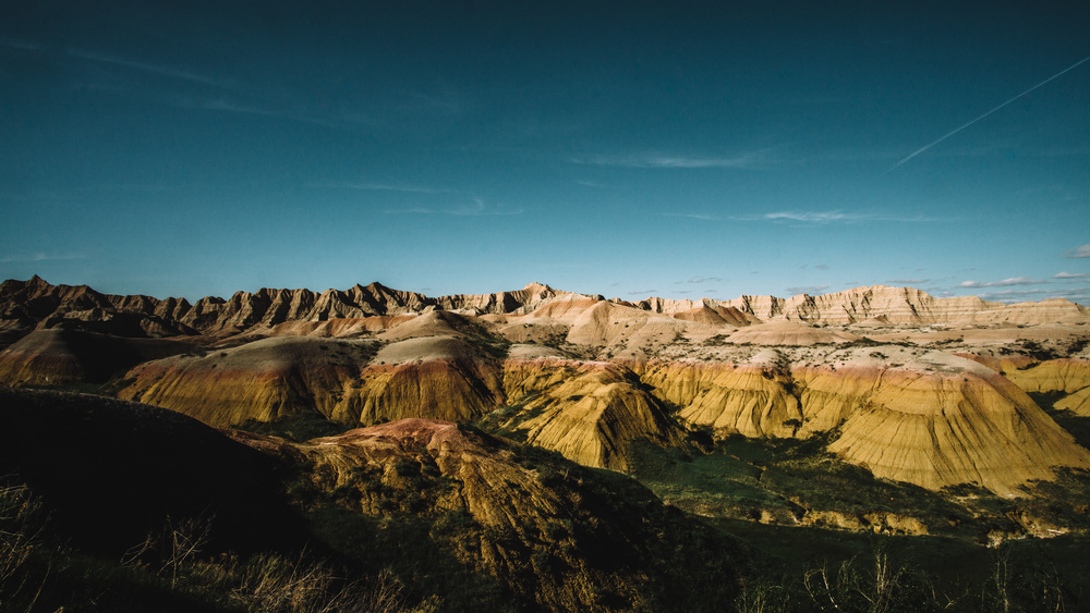
Anyway, keep going and eventually you’ll get to Badlands National Park. Now the more spectacular entrance to the park is from the south: that way you really appreciate what the Badlands really are (and why Wall is called Wall): a huge, impassable rise of rock in the landscape; really a very long wall. Since these lands were so bad to travel through, they earned their name. Anyway, this trip does not enter from that direction, but the next day, you’ll exit that way and will appreciate this view.
Either way, when you stop at the first viewpoint, you will be blown away by the scenery: wild rocks as far as the eye can see and with wild colours (though beige and red dominate). You’ll feel as if you were on a different planet and a strange one at that.
By now it should be late afternoon, so unless you plan to stay in an hotel / motel / BnB in Wall or other nearby town, you should be starting to get ready to hike out. Much of the hiking is cross country and you do not need to get a permit in advance. It is advised to get one from the ranger station (on the other side of the park that you enter from). By the time I would have made it to there, they would have closed and the ranger at the Pinnacles entrance told me to just fill out the backcountry register at the trailhead. So that’s what I did. Since hiking is cross country, you will need a good topological map and a compass. The latter is not really required depending on how deep into the badlands you venture. I simply hiked out from the Conata picnic area trailhead and went southwest along the badlands. So to the south there was open & flat prairie, while to my north the badlands rose steeply — difficult to get lost. I hiked out for 2-3 miles, then cut into a little valley that lead into the badlands (this part is called Deer Haven). I then hiked up the ravines and found a good spot on top of a grassy area. However getting up (and the next day down) the steep sides of the badlands is iffy and potentially dangerous. If it rains or looks like it might be raining the next day, don’t do it — it’ll probably be just one slippery mess.
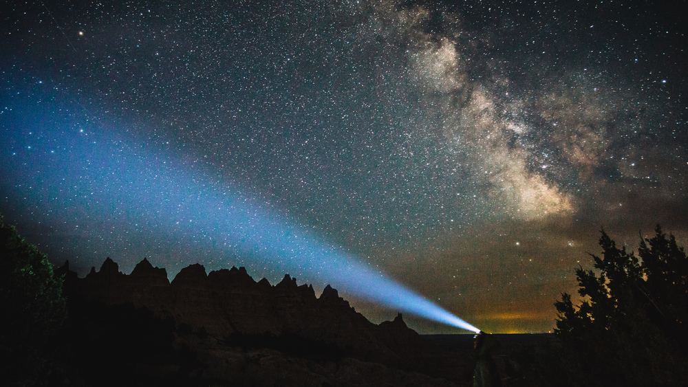
The skies in Badlands NP are famously dark, so make sure to get up in the middle of the night to gaze at the sky. Other than that you night will be quite and peaceful. I was woken up in the morning by the howls of a coyote. Quite eerily beautiful.
Leg 2: Badlands NP, SD -> Minuteman Missile NHS, SD -> Denver Airport
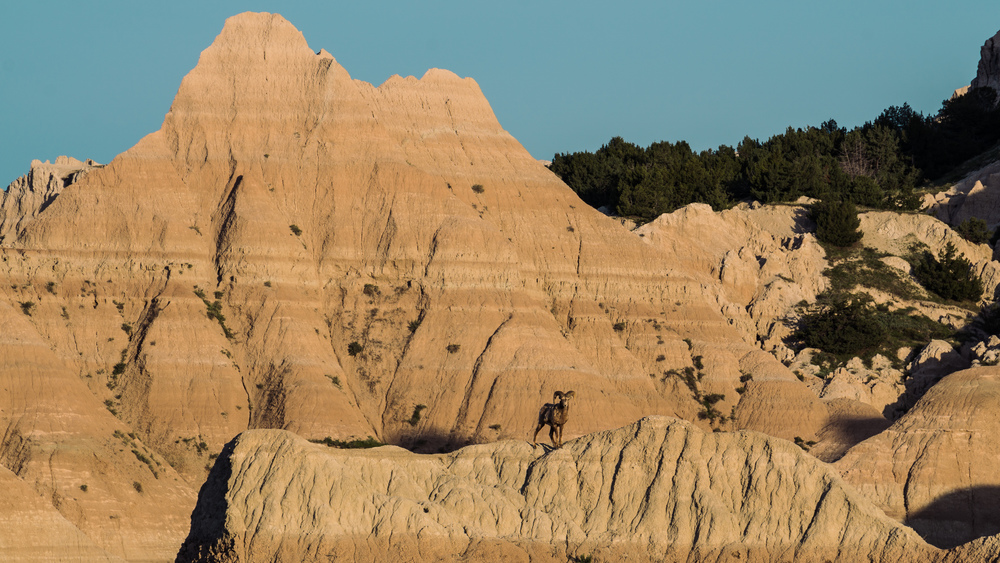
After you had breakfast, pack up your tent, hike back to your car. There’s plenty of deer and bighorn sheep in the park, so keep your eyes out for them. As I came down from my perch high up in Deer Haven, a bighorn sheep just made its ascent of a rock a hundred yards west of me. We both were surprised to be eyeing each other and it was a bit of an uneasy stand-off (those big horns sure look as if they can hurt you pretty badly). In the end the bighorn just kept staring at me as I continued with my descent, then ignored me once I was far enough away from it.
Take your time to leisurely drive through the park, stopping at the viewpoints and taking it all in. It’s a really impressive park, so make the most of it. Go for another short hike (e.g. the Door or the Window Trails near the main visitor center) if you feel like it.
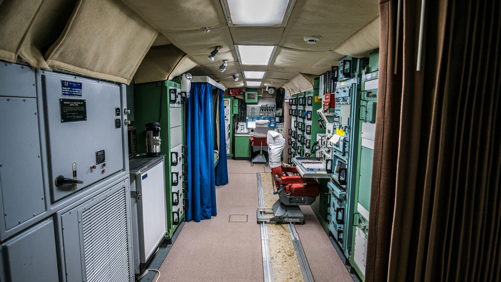
Just a few miles north of the park sits a newly built visitor center for the Minuteman Missile National Historic Site. There you can get free tickets for a tour of the command center, as well as directions to the rocket silos which you can visit on a self-guided tour (both the command center and the silo are a few miles to drive west of the visitor center to get to). The Minuteman Missiles were part of the cold-war nuclear deterrent. It’s not much to see, but quite interesting to visit. It’s all a bit scary when you think that they could have launched the nuclear holocaust from here.
Once you are done, drive back south, through the park, towards Interior, SD. Be sure to stop as you head south to appreciate the wall that is the Badlands as you drive south on highway 377, then west on highway 44. Finally, make your way back to Denver. It’ll be another long, 6h drive.
It’s a lot of driving for a 2 day trip, but it’s all true American Wild West landscapes. And you’ll get to see so much on this trip, it’s well worth the drive. If you’ve got a few extra days, be sure to include stops to Wind Cave NP, Jewel Cave, NM, Custer State Park etc — there is so much more to explore in this corner of the US. There’s also a lot if Native American heritage and history here, not least the Ghost Dance movement and the massacre at Wounded Knee, so it was a bit of a shame I did not have more time. I really only realised how much there was to explore in this part of the world once I was out there, so really should have made a long 3-4 day weekend of it or maybe even a week.
Data files (click on the link, then download whatever format you prefer from the gpsies website):
Leg 1 (Denver, Mt. Rushmore, Devil’s Tower, Badlands): http://www.gpsies.com/map.do?fileId=mrlcsydftzyufvis
Leg 2 (Badlands, Minute Man Missile NHS, Denver): http://www.gpsies.com/map.do?fileId=jdudywwmcbzuuojcComplete Route: http://www.gpsies.com/map.do?fileId=fdjsufuwtpncrhfe
]]>